THE FIRST HANGING. THAT TOOK PLACE IN OREGON COUNTY —AN ACCOUNT OF IT NOW FIRST PUBLISHED — In the year 1857, or thereabouts, there is some difference of opinion as to the exact date, Robert Shehan was hanged at Thomasville, this County, for murder. The crime which he expiated with his life, was committed in Ripley County, between Doniphan and the present site of the Boze Mill, not far from the Oregon County line, at a settlement called Forcia de Mael. The settlement still bears the name of Forcia; we are told. At a horse race in this settlement in 1853, Shehan, who was a violent and reckless character, got into a dispute with a man named Upton and killed him with a knife. He was arrested at once and taken to Thomasville, which was then the county seat of Oregon County, and lodged in jail. Later his case was brought to this county on a change of venue. On one pretext and another his trial was delayed from year to year until 1857. John R. Woodside at that time attorney for the 14th judicial circuit conducted the prosecution, which resulted in a conviction of murder in the first degree. Shehan was sentenced to hang; the day was set for the execution and crowds were gathering to witness the spectacle when word came that he had been allowed a respite by Gov. Trusten Polk. A delay of some months followed and again the day of execution dawned; this time, there was no respite. Rude gallows were erected, consisting of a post in the ground, a stout cross beam about 14 feet from the earth, with a ring at the end through which to pass the rope. The gallows stood just south of Thomasville, on the flat sandy bottom on the south bank of Eleven points river. As hangings in those days were public a vast crowd, running into the thousands, assembled to witness the awful spectacle. In the crowd were most of the citizens who are now numbered among the pioneer settlers of the county, and from whom these details were gleaned. Three of Thayer’s respected citizens are among them. J.P. Woodside, W.L. Hearle, and Jesse Huddleston were boyish spectators, and vividly recall the great excitement that prevailed. The prisoner was brought to the gallows in a wagon, seated upon his coffin. He was accompanied by the sheriff, Wm. Griffith; also by John Carr and Wm. Humphreys, who at his request played the death march upon their violins. Shehan entered into the picnic spirit of the occasion with great gusto, and when the wagon stopped under the gallows, and the noose had been adjusted, stopped the proceedings to call for another drink of whiskey. The sheriff wishing to grant the last wish of his prisoner sent back to town for a pint bottle. When this was finally given him, he mounted the coffin, with the noose around his neck, drank the liquor down and shouted, “I give and bequeath my body and soul to Dr. Griffith!” He reeled on the coffin; the noose was drawn, the lash was applied, and the horses dashed away, launching the murderer to his doom. Women screamed and fainted, and men bowed their heads to shut out the awful sight. Such is the story of the first and to this date the only, execution in the history of Oregon County, the details of which are for the first time now put into print. [Oregon County Tribune, Thayer, Mo., 9 Jun 1899]
CIRCUIT COURT -1858. The State of Mo., vs. William Griffith, Lewis Griffith, Dr. Wm. H. Griffith & Spencer Griffith. Pollute 11 Point River with a dead body in a decaying and putrefying state. Body of Robert Shehan. [Circuit Court Records, Oregon Co., Mo]
Let us go back in time to the late 1920s and early to mid 1930s. Let us take a trip along the dirt roads or wagon trails through the southeastern part of Oregon County. The dirt road is now known as Highway 142.
Along the way, you would find a dotting of mail boxes with such names as Caldwell, Wheeler, Easley, Blankenship, Cypret, Underwood, Thomason, Norton, Jenkins, Brewer, Melton, Sullivan, Worley, Bryan, Williams, McGinis, Adams, Landis, Grabel, Hetherland, Roberts, Young and probably others I do not remember. Very few, if any of these people, still live in the area. In the midst of all these wonderful people was a small store and blacksmith shop known as Billmore. The Blankenships owned the store and blacksmith shop, which was a gathering place on a Saturday afternoon for many of the people in the community, a place to shop and exchange news of happenings and events of the week just past. It was a quiet, serene community where almost everyone was related either by blood or marriage. It was also a very close-knit community with friendly people having so many ways you had to like some of them.
You will find in this area tall trees, green grass, a few rail fences, large springs, and rivers so clear that you can see a pin on the bottom at great depths. If you were visiting there from some distance away (it didn’t have to be very far away), the whole community would throw a big bash for you that became known as the Billmore Community Fish Fry.
The community owned a large seine or net, with weights on the bottom and floats on the top which would reach across the widest area of Eleven Points River. The river, about one mile east of Billmore, flows through the Andy Caldwell homestead. The campground was about one fourth mile south of the Highway 142 bridge that crosses the river. The campground, where the fish fry was held, was a beautiful location; a flat area with tall shade trees, wildflowers, and a spring for good water. A small stream flowing along side a wagon road gave entrance to the campground. This stream provided a play area for small children or a drinking area for unwanted guests who might appear on the scene.
On the day of the fish fry, usually about 9:30 in the morning, several men and a few grown boys gathered near the campground. These twelve or fourteen people checked the net for repairs, or checked the long poles attached at each end of the net for strength and durability, and, of course, they checked the long rope attached to the pole at each end of the net.
The rope was important because four or five good swimmers holding the rope would cross the river at a likely spot. When they reached the other side, the ones of the opposite side would feed the net into the water as the first group pulled the net across the river. One strong man held the pole attached to the rope being pulled across the river. In most instances, the water was swift, so strong people were required to work fast in order to keep the poles and ropes, now on each side of the river, ahead of the center part of the net. Usually, two good swimmers followed the center section of the net to un-loose it if it should get caught on a snag or rock, as it often did.
A lot of planning was required before launching the net into the river. Relatively deep water was required, because it was not so swift in the deep areas, and that was where the big ones were. Yet, shallow water and a relatively flat area was required in order for the men to pull the net to land, hopefully landing a nice catch. If lucky, we would have a few red horse, large yellow, or blue suckers, maybe a jack salmon or two, a few channel cat, sometimes an eel, and, of course, a few turtles and crawdads.
Then we would move on, either up river or down river, for the next drag, which was the distance from where the net was launched to where it was pulled to dry land to unload the fish. The number of drags depended on the number of people attending the fish fry and the number of fish caught in the drags. We never wanted to waste the fish by taking more than needed; we wanted to save some for another time.
As fish were caught, they were rushed to the campsite by a runner where the fish were cleaned and prepared for cooking by some of the busy ladies in camp. The runner would rush back to the river for another catch. Most of the fishing was done within a mile of the camp site.
It was interesting and exciting to watch or be part of the fish drag party as they moved to the next area of the launch. The net was about 150 feet long; it was carried Indian style. By that, I mean one person followed another about ten or twelve feet apart, depending on the number of people doing the fishing. From one drag to the next, the men would move along the river bank looking for a good place to launch. Many of us were barefoot. I can still remember the sharp rocks, thorns, and other obstacles to slow us down.
Some of the drag areas I remember were the Blue Spring Branch upstream, a small river starting from a large spring at the base of the Narrows. This small stream emptied into the Eleven Point River less than one-half mile from where it started.
The area was usually productive, but the water was extremely cold, so we didn’t tarry in that area very long. The next area downstream was just below the island where a drag was made. This drag finished on the east side of the river where the bridge now crosses the river on Highway 142.
Moving down the river you come to the high bank where the river makes a bend just below the mouth of the small stream that runs along the camp site. The high bank near the camp site was a gathering place for swimmers and after-dinner visiting for the older set. The high bank area of the river was another good fishing place. It was treacherous for launching the seine or net because getting down the high bank to the river was a problem. The water was deep and very swift. The current could easily wash or carry the center part of the seine down river faster than the pole holder and rope puller could move with it. However, if we worked fast and were lucky the drag was very productive. It’s interesting that a drag was never more than 100 to 150 yards in length, and often much shorter.
If, by chance, we didn’t have a sufficient number of fish by this time, we moved on down river past the long swift rapids to a place called the Elgan Hole, which was another good productive area. I’m sure this area was named for one of the sons of Andy Caldwell.
Often during the fishing period, someone would come along the river bank with a desire to join the party without helping or getting wet. Well! That was a mistake! Someone in the fishing party would usually hold out a hand to the person on the bank for assistance in climbing up the embankment. This act was pretty well pre-planned, so we had the largest and strongest person in the party to extend his hand. Suddenly, after the two had joined hands, the person on the bank came flying through the air into the water for a good dunking. If the person took this action in good humor, we made him a member of the Perch Club and invited him to dine with us. If he took issue with the action, he was ducked again. He was not invited to dine with us and was often left at the river. No! We didn’t drown him, but he was left wet and in shame.
Of course, this was not the only place in which people were ducked. As years passed, I remember that roads improved, more automobiles became available, and more game wardens were prevalent.
One day, a runner came to the river to inform us that two game wardens were at the camp, waiting to arrest everyone for illegal fishing. Illegal? No, we didn’t know our fishing was illegal! I had never heard of a game warden. Since we already had caught all of the fish we needed, we stashed the seine and went into camp. We found everything in good shape and saw two strange people that we learned later were the game wardens. With aprons on, they were helping the ladies fry the fish.
According to reports we received later, the game wardens had come into camp with a very bad, obnoxious attitude. The ladies were very hospitable and invited them to have dinner with us. The game wardens refused and stated their purpose was to arrest everyone in camp. So a few of the larger, stronger ladies picked up the game wardens and body tossed them into the deeper water area of the small creek that flowed by the camp. When the wardens climbed up the bank, the ladies, with hands on their hips, again invited the wardens to break bread with us. The wardens refused and stated their business. Well, again the ladies put the wardens in the water. This time, I was told, they literally put them under and held them under until bubbles began to appear. When the game wardens came out from under the water this time, they gladly accepted the invitation, and offered their help.
It was a wonderful spread, as they always were, with fish cooked in a large wash pot over an open fire, boiled coffee, cornbread, pies, cakes, and all the trimmings that were prepared by the ladies before they came to the camp.
By the way, we were never bothered with those game wardens again. Of course, there was only one small wagon road that came into camp. If a wagon or two were turned crosswise in the road, the progress of anyone traveling by automobile (as the game wardens did) was impeded.
Those were wonderful days in my memory of southeastern Oregon County. I’m sure that those from the Billmore area who are still living will long remember the Billmore Community Fish Fry. I do. (Golden Wheeler)
In 1968 Congress established the National Wild and Scenic Rivers System. A 44-mile portion of the Eleven Point, free of impoundments and with a largely undeveloped shoreline and watershed, qualified as a National Scenic River. This portion between Thomasville, Missouri, and Highway 142 bridge became one of the 8 initial units of the National Wild and Scenic River System in 1968. About half of the lands within the Eleven Point Scenic River area are private lands, while the remainder of the area is National Forest System land. The private lands along the river are managed by scenic easements to assure protection of their scenic values and natural resources. Public entry to these private lands is prohibited. River users should study the river map and be alert for private property or scenic easement signs located along the river course to avoid trespass. THE RIVER The Eleven Point River meanders through the picturesque Ozark hills of southern Missouri. Its course is cut in the shadows of steep bluffs, through sloping forested valleys and low-lying riparian ecosystems. Barely more than a small stream at its upper reaches near Thomasville, Missouri, it gains considerable width and depth as it proceeds southeastward. Springs pouring from dolomite bluffs or rushing up from a vast network of underground flow systems provide a continuous source of water and beauty. Alternating stretches of rapids and deep clear pools wind around moss-covered boulders and shading bottomland hardwood trees. River birch is abundant along the shore and aged sycamores lean out across the river from their shoreline moorings. In some places, the canopy of green closes overhead. FLOATING ON THE ELEVEN POINT To the experienced canoeist, the Eleven Point is a relatively easy river (Class I and Class II International Scale) requiring intermediate experience. Snags, trees and root wads all remain the most dangerous of all obstacles and, on occasion may require scouting from shore. Although canoes are the time-tested means of travel through fast water, the flat bottom Jon boats are used on the river, primarily for fishing trips. You may encounter some boats with motors. Motor boats are restricted to a 25 hp limit. Canoeists should learn to read the water ahead. White water riffles mean that rocks lie very close to the water surface and you are about to enter a “chute”, where water flows faster. The safest course to follow is the smooth water, shaped like a “V” pointing downstream. Watch out for rootwads! Water rushes under and through the exposed roots of fallen trees and creates a hazardous condition. Learn to avoid obstructions. Back paddle as an aid to changing positions or use “draw” or “pry” strokes to move laterally.
French trappers operated in the area in the eighteenth century, and indeed the Eleven Point River receives its name from the French word pointe, used by early explorers to indicate the point of land marking a bend in the river; this was a way of marking distance.
The Eleven Point National Wild and Scenic River was established in 1968 as a 44 mile scenic river, free of impoundments with a largely undeveloped shoreline and watershed. The river now has 138 miles.
This portion of the river between Thomasville, Missouri and the Highway 142 bridge is near Gatewood, Missouri. It became one of the 8 initial units of the National Wild and Scenic River system in 1968.
The Eleven Point National Wild and Scenic River meanders through the picturesque Ozark hills of southern Missouri. Its course is cut in the shadows of steep bluffs, through sloping forested valleys, and low lying riparian ecosystems. Barely more than a small stream at its upper reaches near Thomasville, it gains considerable width and depth as it proceeds south-eastward.
Springs pouring from dolomite bluffs or rushing up from a vast network of underground flow systems provide a continuous source of water and beauty. Alternating stretches of rapids and deep clear pools wind around moss covered boulders and shading bottomland hardwood trees.
Access to the River: There are currently eleven designated access points to the river by vehicle. Of these access points, 7 are managed to a standard that includes boat ramps and vault toilets. The remaining 4 access sites are managed to a lesser standard to encourage use by those wishing to avoid higher user densities. In addition, there are 8 float camps designated on the river to provide overnight camping for river users.
Who Can Use the River: The river has been designated for both motorized and non-motorized use. The motorized users must adhere to a 25 horsepower limit.
Fishing: There are opportunities aplenty for small mouth bass and pan fish. Special regulations apply. Go to www.mdc.mo.gov for more information. Trout fishing starts at the confluence of the Greer spring branch and the river. Greer is the world’s 10th biggest spring and doubles the size of the river while turning it into a cold water fishery. This is the beginning of the blue ribbon trout section which extends about 6 miles to Turner Mill spring. Flies and artificial lures only are allowed (soft plastic and baits are prohibited) and there is a limit of 1 fish at least 18 inches. There is a strong population in this section of river.
Starts at Willow Springs
To the experienced canoeist, the Eleven Point is a relatively easy river (Class I and Class II International Scale) requiring intermediate experience. Snags, trees and root wads all remain the most dangerous of all obstacles and, on occasion may require scouting from shore. Canoe Rentals: https://www.hufstedlers.com/eleven-point.html at Riverton
The Current River forms in the southeastern portion of the Ozarks of Missouri and becomes a 7th order stream[4] as it flows southeasterly out of the Ozarks into northeastern Arkansas where it becomes a tributary of the Black River, which is a tributary of the White River, a tributary of the Mississippi River. The Current River is approximately 184 miles (296 km) long and drains about 2,641 square miles (6,840 km2)[4] of land mostly in Missouri and a small portion of land in northeastern Arkansas. The headwaters of the Current River are nearly 900 feet (270 m) above sea level, while the mouth of the river lies around 280 feet (85 m)[4] above sea level. The basin drains a rural area that is dominated by karst topography, underlain by dolomite and sandstone bedrock with a small area of igneous rock southeast of Eminence, Missouri. The annual daily mean discharge of the river near Doniphan, Missouri is 2,815 cubic feet (79.7 m3) per second.[4] In 1964, over 134 mi (160 km) of the upper course of the river and its tributaries were federally protected as the Ozark National Scenic Riverways,[5] the first national park in America to protect a river system.
Welch Spring, a first magnitude spring, enters the river approximately 14 miles (23 km) downstream from the headwaters, nearly doubling the flow of the river. Other notable springs to add to the river include Cave Spring, Pulltite Spring, and Round Spring. Downstream from the headwaters approximately 52 miles (84 km) the Current River receives its largest tributary the Jacks Fork from the west near the small town of Eminence, Missouri. Blue Spring, another first magnitude spring, empties into the river, 9 miles (14 km) downstream from the confluence with the Jacks Fork. The Current River is approximately 86 miles (138 km) long when it passes by the town of Van Buren and under U.S. Route 60. South of Van Buren a few miles the Current River receives its second biggest tributary, the largest spring in the Ozarks and one of the largest single spring outlets known in the world.[6]Big Spring empties into the river providing nearly 470 cubic feet (13 m3) of water per second.[7] From Big Spring the river continues southeasterly leaving the Ozark National Scenic Riverways 105 miles (169 km) from the headwaters. The river then flows through Mark Twain National Forest until reaching Doniphan, Missouri and passes under U.S. Route 160. From here the river slows as it exits the Ozark Highlands, the river continues its slow silt laden path into Arkansas where it receives the Little Black River from the northeast before it joins the Black River near Pocahontas, Arkansas.
Canoeing, fishing, horseback riding, and camping are very popular activities along the Current River. The river is fairly gentle and is considered to have mostly class 1 rapids and a couple rated class 2.
Some of the points of interest along the course of the river include Montauk State Park (trout park), Welch Spring and abandoned hospital, Aker’s Ferry, Cave Spring, Devil’s Well, Deer Leap, Rock House Cave, Pulltite Spring, Round Spring, Jacks Fork, Blue Spring, Rocky Falls (on a small tributary), and Big Spring.
Most spring-fed of all the Ozark rivers, the Current may be floated at almost any time of the year, particularly below Welch Spring. On hot summer weekends, the river is usually crowded. Weekdays floats are much more peaceful. Due to the increase in size of the river and the frequency of motor boats below Big Spring, most canoe and kayak trips are made on the sections above Big Spring.
Difficulty: I, occasionally II.
Gradients: general- 4.4; Montauk to Akers – 8.7; to junction of Jacks Fork – 5; to Big Spring – 3.8; to Doniphan – 3.2.
Counties: Dent, Shannon, Carter, Ripley.
Current River I – Mile-By-Mile Description
0.0 Baptist Camp Access on county road off Hwy. YY.
3.3 Ashley Creek on right.
6.5 Parker Hollow on left, fed by Schafer Spring].2 miles upstream.
8.0 Cedargrove Access. Low-water bridge and can1pground.
8.9 Big Creek on right.
11.6 Medlock Spring on right.
12.4 Welch Landing Access.
12.7 Welch Spring, sixth largest in state, on left.
15.7 Akers Ferry Access on Hwy. K. Campground and store.
17.8 Lewis Hollow on right at ford.
20.9 Cave Spring on left. Water at back of cave is 120 feet deep and comes from Devil’s Well via nearby Wallace Well Cave. Devil’s Well, a sinkhole more than 200 feet deep and partly filled with water, is one mile north of Cave Spring.
23.2 Rock House Cave on right. A meander of a cave, cut off by the deepening river valley, it is now more like a natural bridge than a cave and makes a good shelter.
25.2 Pulltite Access. Campground and store.
26.0 Pulltite Spring and branch on right. Just below on the same side of the river, are several other minor but interesting springs, one of which is the “Fire Hydrant Spring” gushing from a small cave in the bluff.
27.0 Boyds Creek on right.
30.2 Jerry J. Presley Conservation Education Center on left, formerly the Alton Club. No access or camping.
32.7 Sinkin Creek enters on left. By putting in at The Sinks, where the creek takes a short -cut through a hill via a cave, 6.5 miles of the creek can be floated in good water. Gradient is 10 teet per mile.
34.2 Round Spring access, campground, spring and cavern.
42.5 Big Creek enters on left.
44.7 Bee Bluff on left.
46.6 Jerktail Landing on right, on county road offHwy. 19. Access and campsite.
51.1 Ebb and Flow Spring, reached by walking 0.25 mile up creek on left.
51.5 Jacks Fork River enters on right. Two Rivers Access (Ozark National Scenic Riverways).
52.3 Old ferry site, access and campground.
56.2 Blair Creek on left.
58.4 Hwy. 106 Bridge.
58.7 Powder Mill, an old ferry site, with access and campground.
60.0 Blue Spring, ninth largest in the state, has deepest blue color. Reached by a 0.25 mile walk up its branch on the left.
63.8 Roberts Field access and campground. Rocky Creek enters on right. The Falls of Rocky Creek, 3 miles southwest of this point, are a scenic attraction of the area.
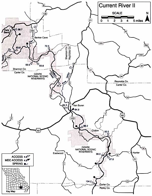
Current River II
58.7 Powder Mill, an old ferry site, with access and campground.
60.0 Blue Spring, ninth largest in the state, has deepest blue color. Reached by a 0.25 mile walk up its branch on the left.
63.8 Roberts Field access and campground. Rocky Creek enters on right. The Falls of Rocky Creek, 3 miles southwest of this point, are a scenic attraction of the area.
66.1 Spring on left.
66.6 Carr Creek and Cardareva Mountain on left.
69.0 Log Yard on left. Access and campground.
69.8 Beal Landing on left. Access.
72.5 Paint Rock Bluff.
77.7 Waymeyer Access on right at mouth of Chilton Creek, on County Road M-151 off Hwy. M.
81.5 Pine Valley Creek, also called Henpeck Creek, on left.
84.3 Watercress Spring Recreation Area. Forest Service and campground.
84.9 Van Buren Riverfront Park Access (Van Buren) and Hwy. 60 Bridge.
89.2 Big Spring. Access and campground. One of the largest springs in the world.
93.5 Clubhouse Landing. Access and campground, on County Road 60-221 offHwy. 60.
97.8 Hickory Landing. Access from Hwy. E at Hunter. Cave Spring-Jordan Spring Branch on left. Jordon Spring, 0.5 mile and Cave Spring, 1 mile up branch.
98.0 Catarac Landing on right. Access on County Road Z-217, off Hwy. Z and Hwy 103.
100.3 Panther Spring on right.
103.2 Bog Hollow. PhiHips Bay and Spring on right. Spring about 0.25 mile from river.
104.2 Gooseneck campground on right. Access on Farm Road 3142-County Road CI0, off Hwy. C.
104.2 Gooseneck campground on right. Access on Farm Road 3142-Counry Road C10, offHwy. C.
105.8 Forest Service campground on left. Bagamaw Bay on right. Limited access road.
107.7 Big Barren Creek on right. Twin Springs 0.75 mile up creek.
110.5 Cedar Creek on left. Forest Service campsite in this area.
112.8 Buffalo Creek on right.
113.0 Compton Camp. Forest Service campsite, on right.
118.8 Deer Leap Recreation Area. Forest Service access on left.
119.3 Float Camp Recreation Area. Forest Service access on left.
120.3 Dun Roven unimproved access on right.
123.8 Hwy. 160 Bridge.
124.0 T.L. Wright Memorial Access (Doniphan) on right. Private campground nearby. Stores, meals, lodging in Doniphan.
129.8 Big Island.
135.0 Goose Lake, a lake-like pool of the river.
136.3 Missouri-Arkansas state line.138.0 Current View. Private access.
The Ozark upland stands as a “hilly island” from 500 to 2,000 feet above the plains between the Appalachian and Rocky Mountains. It spans approximately 60,000 square miles in four states: Missouri, Arkansas, Oklahoma, and Kansas. As a geographical region, the Ozarks evolved from a series of at least three crustal uplifts between 100 million and one million years ago.
Large and small springs feed the swift flowing Current river. Geologists date the origin of the Current to the Cretaceous period some 60 to 120 million years ago. In the beginning, it flowed through an eroded peneplain where its winding channel developed. The Current, like many Ozarks streams, maintained a meandering course during the coastal uplifts that created the hills over a long geologic time period.
The Current River originates at Montauk Springs at an elevation of 1,000 feet above sea level and drops an average of five feet per mile to 250 feet at its mouth. Hundreds of springs empty into the Current and supply more than 60% of its water. They range in volume from a few gallons a day to an average of approximately 279 millions a day at Big Spring. In 1920, the state of Missouri established parks at Big Spring and several other large springs, including Montauk, Round and Alley springs because of their natural scenic beauty.
Development of the Current River region involved its growth as both a homeland and a hinterland. Homeland describes a place of one’s native or longstanding residence. The river strongly influenced the nature of the homeland, for the geography in large part dictated the location of settlements and attracted a fiercely independent people content to live on the fringe of an increasingly complex civilization. The river and hilly landscape restricted settlements to the terraces above the floodplain and hollows. Close-knit communities developed within the deep valleys or hollows, but the terrain, to a degree, isolated the populated hollows from one another.
A hinterland refers to an undeveloped area that supplies raw materials for trade or manufacturing in developed areas. For example, at the time of initial European exploration, Native Americans used the Ozarks Courtois Hills as a hunting ground. The French and then Americans moved in, extracted lead, and searched for other minerals. In the late nineteenth century, large corporate commercial interests harvested much of the white pine timber. The extraction of natural resources altered the homeland by increasing the population, introducing new transportation and communication technologies, depleting its resources, and in general reducing the area’s isolation.
(Pappy logging and sending the logs down barges in the rivers).
Prehistoric Presence in the Riverways
Early Manprior to 12,000 BC
Paleo-Indian 12,000 to 8,000 BC
Dalton8,000 to 7,000 BC
Archaic 7,000 to 1,000 BC
Woodland1,000 BC to 900 AD
MississippiAD 900 to 1700
Dr. Chapman: The Archeology of Missouri
Before 12,000 B.C., ancient hunters roamed parts of Missouri in search of the great mastodons and other game. There is very little evidence of human occupation in the Current River basin before the development of the Dalton cultural tradition 4,000 to 5,000 years later. A few signs of the early nomadic Paleo-Indian hunters exist. Recent archeological research, however, demonstrates a rich Archaic, Woodland and Mississippi heritage along the Current River.
After the extinction of the great mammoths, people began to subsist on foraging for nuts and berries in addition to hunting. A transitional “Dalton” period of approximately one thousand years introduced the transformation in Missouri. People continued to live in small nomadic bands, consisting most likely of related families, and moved frequently in the quest for food. They hunted small animals such as deer, rabbits, squirrels, and raccoons. They also gathered wild animals and fruits using mortars, manos, grinding slabs, cupstones and hammerstones.
Along the Current and Eleven Point rivers, the discovery of serrated knives and Dalton points at several prehistoric sites, including Akers, Powder Mill, Alley Spring and Jerktail Landing suggests people of the Dalton tradition inhabited the region.
Spanning an estimated 6,000 years, the people of the archaic period introduced more specialized foraging and more complicated social organization. During the early phase, foraging practices supported a semi-nomadic existence with family groups traveling from camp to camp in small defined hunting grounds where they selected campsites based on the seasonal availability of different plant foods. They also fished and collected shellfish. In the middle phase, tools and garments, such as small sidenotched projectile points, grooved axes and twin fabric sandals were introduced.
In the late phase, people settled in larger groups in campsites of one to four acres and developed more complex social organization. They also reduced their emphasis on hunting and turned to more plants, such as roots, the cambium of trees, and prairie potatoes, for sustenance.
The current River valley was widely inhabited by Archaic people who commonly settled the terraces above the flood plain of the major streams of the river. Prehistoric groups populated Round Spring, Akers, Owls Bend, and Chub Hollow.
The territorial border of the Woodland Culture primarily stretched east of Missouri to the Atlantic coast and from central Canada to east Texas. Across this vast region, the early Woodland culture had limited contact with the Current River region. The middle Woodland culture developed a trade network that reached west to the Rocky Mountains and south the Florida and the Gulf of Mexico including farming and large ceremonial earthworks.
In late Woodland, Ozarks villages grew larger and more isolated, and the inhabitants developed some horticulture. Yet Ozark people continued primarily to subsist from hunting and gathering. Pottery has been found down the Current and Jacks Fork Rivers.
During the emergence of Mississippian culture, a thriving population resided on the Current River and eastern Ozarks. These people developed shell-tempered ceramic and short-stemmed arrow points, approximately 100 to 150 years before these traits spread.
Along the Current and Eleven Point rivers, archeologist have identified three kinds of Emergent Mississippian sites-ceremonial centers, small villages, and temporary campsites. About 30 miles above the confluence of the Eleven Point and Black Rivers, Pigman mound is the largest ceremonial center. Small villages were located at Shawnee Creek, Round Spring, Isaac Kelley and Owls Bend and Goosnect sites. The residents of Shawnee Creek lived in rectangular wall trench houses like those common in the Mississippi River alluvial valley.
During the eleventh century, Mississippian cultural groups began abandoning their villages on the Current river. There is very little evidence of Missippian people near the Current River after A.D. 1250.
Soon after 1350, almost 200 years before Hernando De Soto entered northeast Arkansas, the Mississippian culture disappeared from this region. Several willow leaf arrowheads found in the Current river basin imply that Native Americans used the area as a hunting group between 1500 and 1650 when Europeans began exploring North America.
The Osage Indians were dominant in the area and fought other tribes and the Spanish explorers but traded with French trappers and traders in the early 18th century. The Indians received guns, ammunition, blankets, and other goods. A major trade route of the Osage to St. Louis crossed the lower Current River in Ripley County. By the early 1800s the Osage gave up their Missouri and Arkansas hunting grounds and eastern tribes, the Cherokee, Delaware and Shawnee dominated the lucrative Ozark trade network until approximately 1830. Some Shawnee established villages in 1812-1837 on the Jack’s Fork River.
By the 1830’s, most of the Delaware and Shawnee had departed the Ozarks. Historical maps and other literary sources report at least ten Indian camps and villages in the Current River valley during the first decade of the nineteenth century.
Early Settlement Rural Community on Ozark Frontier, 1815-1850
The early American settlers in the Ozarks, were native-born Americans of Scotch-Irish ancestry. They adapted their “stockman-farmer-hunter” economy to the wooded hills of the Current River basin. Before the invasion of land speculators, the Civil War, the railroads and large-scale corporate lumber, the southern uplanders planted their hill and river communities with little contact with outside society.
Up to 1850, 98 percent of the people who migrated followed three basic paths: a central route from Kentucky and Tennessee, a northern route from Illinois and Indiana, and a southern one from Alabama and Arkansas. Records of pre-1820 are sparse. During his 1818-1819 excursion through the Ozarks, Henry R. Schoolcraft said that “many plantations and farms” occupied the banks of the Little Black, Current, Eleven Point and other rivers of the area. The first pioneers included Isaac Kelley, Zimri Carter, and Thomas Boggs Chilton, whose families became long established and prominent along the riverway. A variety of important factors, chiefly geographic constraints, the self-sufficiency nature of the economy and sock ties, influenced the selection of homesites. Along the Current, the American settlers judged the terraces above the floor plain as more attractive locations. Herbert Clendenen noted: “These sites had easy access to water, immunity from flooding, gently inclined, tillable slopes and an unlimited upland for grazing and foraging stock.”
Between 1820 and 1840, most homesites were scattered in an area bordering to the north and south by Round Spring and Owls Bend on the Current and to the west by Alley Spring on the Jacks Fork in areas recently vacated by the Delaware and Shawnee. They along with a few Creek, farmed, raised livestock, and hunted here. Their lifeway resembled that of the white Ozark frontier settlers and as historian Lynn Morrow stated, “squatters tailed the migrating eastern tribes and benefited from the land and building improvements abandoned by them along the trek westward.”
Along the upper Current, above Van Buren, a frontier self-sufficiency prevailed where plain folk got a living by herding, hunting, farming, and trading or economic generalists. They most often occupied small forty- to eighty-acre farmsteads with several acres fenced off for crops. They relied on meat from domestic livestock and to a lesser degree from wild game. They raised both hogs and cattle, but hogs were the staples. These were called generalist farmers.
In the lower Current River valley, before Van Buren, the presence of larger commercial farms and some farms considered plantations marked a contrast from the upper Current self-sufficiency. The Current River widened in the south and created wider more fertile alluvial valleys. Early settler such as Zimri Carter and Isaac Kelly selected this choice land for their relatively large plantations during the first decades of the nineteenth century. The lower Current was navigable for small boats and barges throughout the year providing outside markets for the crops of the larger commercial farms. Slaves and local barter goods like pelts, agri products for store goods helped the economy.
Family clusters drew people to the area as an important cultural feature. Small rural hamlets and mill sites served as meeting places vital to the sense of community in the isolated Ozark frontier. They consisted of a store, a grist mill, possibly a distillery, and seldom more than eight log dwellings. In rare instances, they also included a blacksmith shop. The gristmill sites, where settlers frequently visited to have their corn ground, were fundamental to local self-sufficiency. Three basic mill technologies–hand-,animal, and water powered mills existed in the Current Valley. Some early settlers relied on hand mills. (P 34) Before 1860, at least ten grist mills and six sawmills operated in the Current River valley.
One unique settlement was in the Irish Wilderness established by Father John J Hogan to improve the lives of poor Irish railroad workers and domestic servants around St. Louis. The Catholic settlement was along the creeks of the Current and Eleven Point Rivers and straddled the border of Oregon and Ripley counties. By 1859, about forty families had migrated but the settlement lasted less than a decade. They had the misfortune to settle on a roadway where both the North and South soldiers traveled including outlaws who hid in the wilderness. They also suffered from prejudice against Catholics. They eventually left due to the Civil War and unrest.
After 1880, large-scale timber operations entered the Ozarks and, more than any other force, developed the area as an integrated part of the growing national economy. The availability of quality pine timber, the expansion of of railroads, and the low cost of extraction, and eventually depleting much of the pine forests. The Current Local, the Van Buren newspaper, called the Grandin mill the largest in the state and claimed that in 1894 it produced more lumber than any mill in the country. By the turn of the century, the Missouri Lumber and Mining Company employed 1,000 of the 5,886 lumber workers in Missouri; in 1905, the mill’s employment peaked at 1,500 workers.” They built pre-fab houses that were transported by rail and were rented for one dollar per room per month.
They floated timber down waterways to transport logs to the mills. They hauled the logs by mules and piled them along the shore. Then, crews gathered a large number of logs and when the water level permitted, floated them downstream. For example, in 1900 a lumber company organized two large river drives that each transported more than on-half million feet of lumber in flotillas of approximately 15 miles long. They did not raft or tie the timber together, but rather ran them loose down the swift-flowing and winding river. A large crew of drivers followed the timber downriver, and they were responsible for breaking up log jams, often by dynamiting.
A number of hazards made transporting timbers through the rugged Current rivers by tram and down the river were risky. Because of the temporary nature of tram tracks, the quality ws minimal, travel over the lines was rough and bridges were not always able to withstand flash floods which could stop operations for days. Violent floods broke up log drives. They sent logs careening downstream and they had to be brought back at considerable expense or bought back from lumber companies downstream.
My Grandfather, John McFarland Underwood, worked at logging and moving the logs down the Eleven Point River where the wood helped build the homes in Imboden, Arkansas.
Lumbering also involved oak, hickory and other hardwoods. Hacking railroad ties was a major enterprise among small operators. They also harvested oak for flooring, wagon wheel hubs cooperage and other wood products. The hickory was taken out for tool handles.
The large-scale corporate pine lumber developments between 1870 and 1920 were the major catalysts of change in the Current River area. Instead of producing tens of thousands of board feet of lumber a year like the old water-powered sawmills, the corporate organized steam-powered mills annually produced millions of board feet.
Toward the end of the nineteenth century, railroad, lumber and mining corporations developed the Current River valley into a hinterland of the expanding national economy. They created thousands of jobs and fostered unprecedented prosperity. New technologies in transportation, communication, and appliances all reflecting a quickened pace of living occurred. New institutions, such as public schools and organized churches, reflected the values of new migrants to the area. Farms grew, especially fruit farms coined “Land of the Red Apple.” The peach industry proliferated in Koshkonong. Doniphan was the leading commercial center of Ripley County and the largest town on the Current River in Missouri. Doniphan had two restaurants, two newspapers, a meat market and a shoemaker. Then they had a cigarmaker, barber, jeweler, dressmaker, photographic, music teacher, undertakers and even more telling of the nature of change in the post-railroad Ozarks, a money broker.
Communications improved via newspapers, enhanced mail service, telegraph, and eventually telephones as early as 1907.
The large lumber companies started leaving in the early 1900’s after deforestation had taken the trees and collapsed the industry. Smaller companies removed trees until the accessible forest was largely gone by 1930. The rivers provided transport to railroad hubs via paddle boats and floating the ties down river. The State of Missouri in 1909 regulated the number of ties in a drive to 50,000 then outlawed them altogether in 1919. No other industry developed to replace the timber economy. The destruction of the forest was a major cause of the declining wildlife population. Deforestation, first by large pine operators and then by small mills and individuals, started a cycle of soil erosion. Annual burnings, over-grazing, and plowing all contributed to laying bare the soil, and the topsoil, followed by the gravel beneath, washed down the hills into the river. The runoff destroyed fish spawning sites, food and habitat.
The area turned to tourism as economic salvation focusing on the areas scenic beauty and recreation of the rivers. Carter County Fishing and Shooting club took trains from the old lumber transport until 1930. The expansion of state and federal government intervention in the development of the Current and Jacks Fork Riverways into a recreation ground for nature-seeking urbanites denominated the history of the are after 1920. The U.S. Forest Service introduced the scientific management of timber; the U.S. Army Corps of Engineers developed hydroelectricity from the rivers; and the National Park Service established a park to preserve the Current River environment. All emphasized the development of recreation.
The railroad tracks and stations were largely abandoned. Increased production of automobiles created the need for better roads, highways and bridges eliminating the ferry traffic.
INSERT: FISH FRY STORY.
In 1932, the federal New Deal program known as the Civilian Conservation Corps (ccc) and took on intensive development of the state parks along the rivers. They built roads, buildings and established pumps and telephone lines. They removed debris and cleared hundreds of acres of picnic and recreation areas. They built flood control dike systems, latrines, picnic shelters, cabins, garages and homes. They laid out trails and built stone ledge walls to keep animals out.
Developers built resorts along the rivers involving activities ranging from fishing, boating, and horseback riding to music and dancing. Local entrepreneurs organized businesses to outfit and guide boating excursions after the establishment of the state parks. Most operations used wooden johnboats between 1920 and 1950 as they were inexpensive to build. Some fishing parties purchased the boats from outfitter and abandoned the crafts after floating downstream which led the friction between outfitters.
The 1930’s was a desperate time for hillbillies except as a haven for whiskey running. The increasing poverty of the Depression years resulted in growing support for a national forest and federal employment programs that would accompany their creation. The national forest acreage increased to more than 3,000,000 acres. The establishment of the national forest did bring jobs and money into the Ozarks. Between 1930 and 1960, conservations and local opponents for the Corps’ dams devised their strategies to preserve the Current as a free-flowing river. Harry S. Truman used the area as campaign headquarters when running for the Senate. The second world war delayed development of the dams. They won the battle as did the same battle over the Eleven Point river dam construction. After much fighting at the local, state and national levels, President Lyndon B. Johnson signed the legislation founding the Ozark National Scenic Riverways and created a new type of riverine national park out of the Current River homeland. Four years later Congress passed the Wild and Scenic Rivers Act in which the Eleven Point was designated one of the new scenic rivers and remained under the jurisdiction of the U.S. Forest Service.
I just got my 01/14/2016 copy of the South Missourian News with the article about the unmarked graves on George Martin’s farm. I was raised on the farm adjacent to that farm and there were Civil War-era graves a few hundred feet beyond our property line on property once owned by George Martin. I just asked my brother Mike a few months ago about those graves and he remembers them. Mike and our other brother Harvey played in that area as kids, as did our older brother Dane and our life-long friends Jerry and James Martin. One of the graves had an upright headstone with the name Elizabeth Taylor on it with years in the Civil War era; her birthdate or date of death was November 28.
The “Allen” that Granny Blue was married to for a short time is an ancestor of the Archie Allen family. My brother Harvey has a copy of a letter from Granny Blue that gives a brief summary of her history in the area. The Allen Brothers’ Farm (aka Crow Hill Farm) has a very old log cabin still standing, although barely, that we have always used as a barn. It was the original house at that site. After the current house was constructed, the log cabin was moved from its original foundation to about 300 feet back from the road where it still stands today. I suspect Granny Blue (and one of her three husbands) lived in that cabin at one point. There was another log cabin back on the farm that was dismantled in the ’40’s or ’50’s and I know it was where one of my dad’s great uncles–N.B.Allen’s father, I think–lived.
On Warm Fork River, just upstream from the George Martin/Dan Cover farm, is a long, deep, peaceful water hole we, since the early 1950’s, have known as Granny Blue Hole, an excellent location for fishing and swimming. We kids of the 1950’s almost always had a rope-swing hanging from one tree or another. We frequently floated in a flat-bottom boat from Sloan’s Ford (north of Hwy 19) or Green Lantern Bridge on Hwy 19 to points south: The Old Iron Bridge (recently demolished), N.B. Allen Ford (sometimes referred to as Cover Crossing), Two-mile Creek, Third Cut or Shelby Hole (just upstream from Mammoth Spring.) A few times, we floated on down to Cold Springs, south of Mammoth. (My most recent float trip was in 2014.) N.B. Allen was related to Granny Blue’s husband. He (N.B.) surveyed the area when it was first being settled. The first settlers who actually “settled,” Allens, built a house and lived on the north side of the spring at Mammoth Spring. After finding out they were in Arkansas, they packed up and moved a couple miles up “the warm fork” of the Spring River, permanently settling on Warm Fork River where wagons used to cross the creek on the creekbed instead of a bridge or spillway, at N.B. Allen Ford.
Some information in the previous two paragraphs came to me from my father and grandfather. Some came from the copy I have of Granny Blue’s letter.
This is my first correspondence with your association, so I don’t know how much of this history you are familiar with or how much you know about Granny Blue and the Civil War graves. Pictures on your site seem to be of the Clifton Cemetery, just east of the Green Lantern Bridge, final resting place for several Allens including N.B. (There are also Allens interred at the cemetery located inside Mammoth Spring State Park.) But I did not see pictures of the Civil War graves that I know are located on what is now the Cover farm, although the team from Rolla may have been working at that very site.
If you have any questions you think I could help you with–or have any information you could help me with–I would enjoy communicating with you.
I really enjoy stories about the history of Oregon County, especially those of the Civil War era. I hope OCHS will keep up the good work!